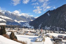
The south ridge of the 3,369 m high Sasso Nero in the Zillertal Alps levels off to the Valle Aurina valley
Image gallery: Sasso Nero
The Sasso Nero (Schwarzenstein in German) is located on the boundary between South Tyrol and North Tyrol and levels off to the Valle Aurina valley to the south-east. The mountain is characterised by the huge glacier areas between the crests. In 1852 the Sasso Nero was climbed for the first time, back then from the Valle Aurina valley.
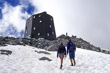
Today the mountain can be climbed from Ginzling in the Zillertal valley (North Tyrol) or from Lutago in the Valli di Tures e Aurino valley. The route leads you first to the Rif. Vittorio Veneto al Sasso Nero mountain hut (2,922 m a.s.l.), the highest located mountain hut of the Zillertal Alps and then across the Rotbachkees glacier to the summit (about 1.5 hours). A typical alpine tour to one of the dominating peaks of the Valle Aurina valley.
Neighbouring peaks of the 3,369 m high Sasso Nero in the Zillertal Alps are the Großer Mörchner (3,283 m), the Floitenspitzen and Monte Lovello (Großer Löffler) (3,379 m).


