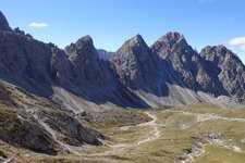
To reach the peak of the panoramic Golzentipp from the mountain station near the Malga Conny hut, only 220 metres in altitude and 2.5 km easily walkable paths have to be managed
Image gallery: Hike to the top of Mount Golzentipp
The cable car takes us from Obertilliach in the Tyrolean Gailtal valley up to the Connyalm mountain hut at 2,095 m a.s.l. The gravelled path no. 44B proceeds through the landscape with alpine meadows up to the Laba reservoir and further to the Jochsee lake. Soon afterwards, the junction with the Gailtal High Route follows. From here only 100 metres in altitude more are lacking until the 2,317 m high peak of the Golzentipp mountain where we can enjoy a gorgeous view from the Dolomites to the Grossglockner and the High Tauern.
The path entirely proceeds above the timberline and shows no difficulties. It’s more a walk at a dizzy height than a mountain hike. But the beauty of the wide meadow landscape and the breathtaking view make the walk an experience. It’s also possible to extend the hike on the Gailtal High Route.
Author: AT
-
- Starting point:
- Connyalm mountain hut (mountain station of the cable car)
-
- Time required:
- 01:45 h
-
- Track length:
- 6,0 km
-
- Altitude:
- from 2.098 m to 2.317 m
-
- Altitude difference:
- +272 m | -272 m
-
- Signposts:
- 44B, 44, Gailtaler Höhenweg, Golzentipp
-
- Destination:
- Golzentipp (summit)
-
- Resting points:
- Connyalm
-
- Recommended time of year:
- Jan Feb Mar Apr May Jun Jul Aug Sep Oct Nov Dec
-
- Download GPX track:
- Hike to the top of Mount Golzentipp
If you want to do this hike, we suggest you to check the weather and trail conditions in advance and on site before setting out.


